7303-017-062
Tiger-240 VTOL Drone for Mapping and Surveying - image 1
  • Tiger-240 VTOL Drone for Mapping and Surveying - image 1
  • Tiger-240 VTOL Drone for Mapping and Surveying - image 2

Tiger-240 VTOL Drone for Mapping and Surveying

Highlights:

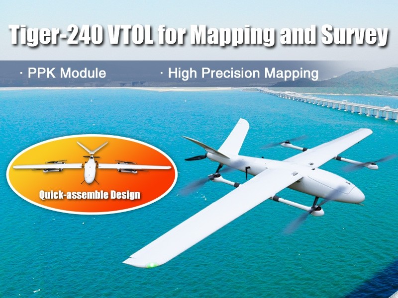
  • Cruising Speed:20 m/s

  • Drone Length:1180 mm

  • Working Temperature:-20°C to +60°C

  • Manufacturer Warranty
  • support Expert Support
  • Free Shipping

Overview

It is a high-performance drone equipped with a PPK module and a 30km long-range data link, enabling high-precision mapping and surveying. The aerodynamic design ensures low air resistance. The drone features a PPK module and a P9 900MHz 30km data link. The PPK module supports up to 25Hz RAW data recording. The positioning accuracy is less than 0.01m.

Specifications

  •  Standard Weight of the Drone: The takeoff weight of this small-category drone is about 7 kilograms.
  • Wingspan of the Drone:  Talking of the total wingspan of this drone, it ranges up to 2400 mm.
  • Maximum Height Attainable: The maximum height at which this drone can fly is around 400 metres.

Top Use Cases

  •  High-Precision Mapping: For situations requiring high-precision mapping, this small and durable drone is truly worth its weight in gold.
  •  Superior for Surveying: It is not just good for mapping areas and terrains, but it can also come in handy for conducting surveys and inspections on construction sites.
Related Tags:
Surveying Drone Mapping Drone

Confused About Aircraft Training or Careers?

Whether you're aiming to be a pilot or aviation expert, we’re here to help you choose the right aviation path.

Chat with Expert Book Free Counselling

Explore More Drone Products

Browse similar UAVs and add-ons trusted by students and professionals alike.

Share

half-star-solid phone